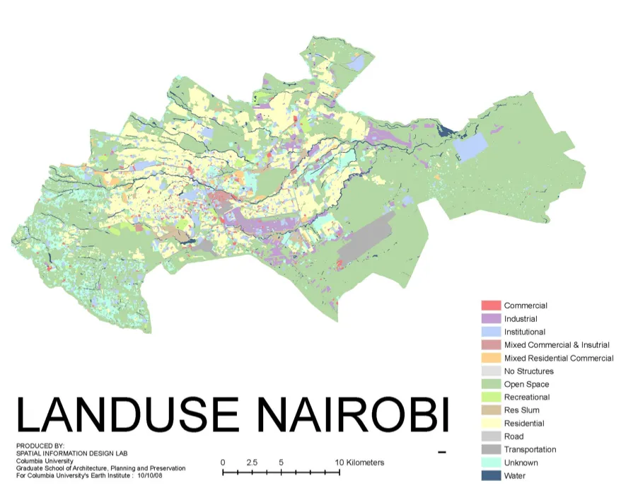
One of the first observations made when CSUD began its work in Nairobi was the lack of available maps and GIS data on various urban characteristics. Many times, if the information was available, it was not for public dissemination and/or use. Our partners at the Department of Urban and Regional Planning (DURP) at the University of Nairobi had also faced similar obstacles when trying to access maps and GIS data. Interested in improving access to public information, CSUD hired the Spatial Information Design Lab (SIDL) at Columbia University to digitize plat maps of Nairobi and specifically focus on the land use, building density and road network for the area known as “Core Nairobi.” The result yielded detailed maps as well as a thorough database of these characteristics. In 2010, CSUD collaborated with partners at DURP to verify and update the data, resulting in a more accurate and detailed land use map of Nairobi.
CSUD created a wiki-site at: http://nairobigismaps.wikischolars.columbia.edu/ to provide public access to both the original data sets and maps (2008 and 2010), as well as the updated data sets and maps created by DURP in 2010. Both data sets were officially launched in 2010 when CSUD and DURP and held a mapping roundtable discussion in Nairobi to introduce the wiki-site to Nairobi-based organizations active in mapping techniques as well as to faculty and students. The discussion highlighted the barriers to data and how access could be improved. With this in mind, Williams (SIDL), Marcello (CSUD), and Klopp (CSUD) wrote, “Open Source Nairobi: Creating and Sharing a GIS Database for the City of Nairobi to Provide Equal Access to Information,” sharing the experience of generating a GIS database for Nairobi. This research illustrated that sharing data has the potential to shift power dynamics during the urban-planning and policy-making process, an important element in our concept of strategic policy networks.